 WGM-301U GPS接收机说明书
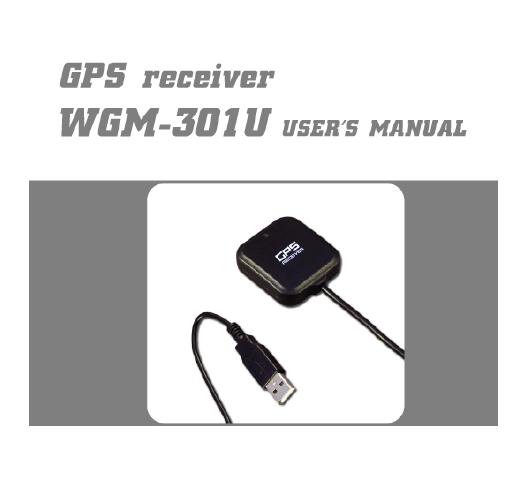

WGM-301U GPS接收机说明书
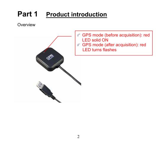
Table of contents Contents Part 1 Product introduction 2 Part 2 Features 3 Part 3 Technical specifications 4 Part 4 Safety notes 6 Part 5 Quick user guide 7 Part 6 Operation notes 8 Part 7 Access Tool installation guide 10 Part 8 Software interface 21 Part 9 Trouble shooting 23 Part 10 PIN’s definition 25 1 Part 1 Product introduction Overview GPS mode (before acquisition): red LED solid ON GPS mode (after acquisition): red LED turns flashes 2 Part 2 Features WGM-301U is a high sensitive GPS receiver with internal antenna. ATMEL ATR0625 used in its core is high-tech component which are useful in navigation, security tracking purpose, map making and other agricultural needs. USB connector ensures easy linking with other electronic devices .The GPS acquisition status, the last record of time and position can all be stored in unfailing memory. It has 16 GPS channels and its low power-consumption WGM-301U can boast of its smallest size ever with fullest features in the world. WGM-301U uses ATMEL ATR0625 GPS module. Maximum 16 channels can be acquisitioned quickly. Internal decode ”SBAS” is used excluding the need for external hardware in receiving SBAS signal. System supports NMEA0183 2.3 for data transfer. It is designed to be water-proof. The software “G-Rays Tool” provided along with the product can simplify operation. Versatile design aimed for car/personal navigation, fleet management, AVL, tracking and mapping purpose. If ps2 connector is used (WGM301P), it must conform to PIN’s definition on Chapter 10. 3 Part 3 Technical specifications General specs Chips: ATMEL ATR0625 of least power consumption with highest sensitivity. Number of channels: Receivable of signal from 16 satellites simultaneously. Receiving frequency: 1575.42 MHZ. Receiving code: L1, C/A code. Sensitivity: -158dBm. Positioning time (average) Re-acquisition time: 0.1 sec. Cold start time: 34 sec. Hot start time: 3.5 sec. Data update rate: 1 Hz (default). Accuracy 2.5m CEP(Stand-alone, S/A off). Supportive GPS features: Accessible to SBAS. 2.0m CEP (SBAS). Dynamics: Maximum 4G (G is gravity unit) Environmental specs Working temp range: -10℃~60℃ (internal temp.). 4 USB specs Interface type: Standard USB connector of computer. Universal Asynchronous Receiver/Transmitter (UART). Data transfer rate: Auto baud rate (1200, 2400, 4800, 9600, 19200, 38400, 57600,115200 bps). Data output: GPS internal standard axis WGS84. NMEA-183 Version 2.3 ASCII output GPGGA GPGLL GPGSA GPGSV GPRMC GPVTG GPGRS GPGST GPZDA 5 Part 4 Safety notes GPS (Global Positioning System) is provided by the United States government. Its accuracy may varies depending on special conditions (area at war or if it is blocked). Any control by USA will affect this system and its accuracy. If installed on the transportation device, driver must not operate this while driving. GPS performance is affected when satellite coverage is degraded as near a high-rise building, in the tunnel or under a cover. Personal replacement of components and re-structuring of this is prohibited and may result in loss of legal usage. Operation of this device is strictly prohibited in highly explosive environment such mining, in-flight or other unauthorized area against use of this. Avoid exposing this at places of high temperature and humidity. Return to original dealer immediately if it emits strange smell or fume. 6 Part 5 Quick user guide Package: WGM-301U, installation Disk and User’s Manual. WGM-301U Operation USB driver must be installed first (G-RaysI Tool included). After connection to USB port of computer, place the WGM-301U at suitable area where it can best receive GPS signal for acquisitioning. Insert to USB host and WGM-301U will start acquisition. 7 Part 6 Operation notes WGM 301U will do self-check once it is powered. GPS start to work and red LED turns solid ON. GPS automatically starts acquisition. If sky is clear overhead, it requires only 34 sec for acquisition. (If the data in its memory is still valid, it needs only 4~33 sec). After acquisition, WGM301U starts output data of position, speed and time in NMWA0183 format. Following success in acquisition, the red LED turns flash. For the first time if it is placed at the area well exposed to the satellite signal, this device requires approx 13 min (theoretically 12.5 sec) to receive or update Almanac. Refer to trouble shooting guide when signal is not received well. If WGM-301U formatting the internal data is not correct, or if satellite data has been deleted, it takes longer time to position. But under the following conditions, it can take even longer time to do cold start. 8 If it is not in use for over 3 months (the almanac too old). If the recorded data is over 500 km. After positioning, WGM-301U transfers navigation data thru export interface as below. Latitude Longitude Altitude Speed Date Time(UTC time) Estimated error Satellite status Receiving status 9 Part 7 Access tool installation guide 1、Execute GPS CD, then click on“WGM301" 10 2、Click on "Access Tool" 11 3、Click on "Install G-RaysI Tool (PC)"。 12 4、Click on “Next” to install ”G-Rays Tool”,the USB driver will install at the same time. 13 14 5、Use USB cord to connect WGM301 to the USB port of computer. Computer will automatically check it and seek driver software automatically. After USB device is connected, if PC requests “device manager”, follow the procedure below. Click “next”. 15 6、If the screen display as below. Click “continue anyway”. 16 7、If the screen display as below. Click “OK” Then click “Browse” and select the path as: ”C:\Program Files\G-RaysI\USB Driver”; then click ”OK”. It will complete all installation processes automatically. 17 8、Installation completed. 18 9、To check the installation status, go to the “device manager” . As in the illustration (marked in red circle), the USB driver is correctly installed to PC. The illustration also shows USB being transferred to Com Port assigned as COM 7. In the future, whenever the WGM301 is connected to USB port on the computer, the COM 7 acts as the interface for data communication. 19 20 Part 8 Software interface WGM-301U Software Interface output as below. NMEA ((National Marine Electronics Association) 0183 Version 2.3 (ASCII Format). Baud Rate: 1200~115200 bps, 8(Data Bits), Stop bit, No parity. NMEA-0183 export data NMEA Explanation GPGGA (factory default) GPS Data GPGSA (factory default ) GNSS DOP GPGSV (factory default) GNSS number of satellites GPRMC (factory default) GPGLL Recommended minimum specific GPS data Geologic position latitude/ longitude 21 GPVTG GPZDA Course Over ground and ground speed Date and time 22 Part 9 Trouble shooting The GPS signal will become weak under the following conditions. If the vehicle enters the tunnel. The GPS signal transmits linearly down to earth and its signal is blocked out in this situation. GPS satellite coverage gets poor because of high-rise building or thick forest. Even though WGM-301U can receive reflected weak GPS signal, the data might be less accurate. The sun shade in the vehicle can partially block out GPS signal and effect good reception. The GPS satellite is under control of USA and the accuracy might vary depending on some special purpose (as may be required by USA). It is a normal situation when GPS data displayed by the receiver device shows a big difference from real position because of unstable atmospheric condition which causes GPS axis to drift from actual map axis occasionally. 23 Some navigation software can only decode latitude/latitude from NMEA0183 provided by logger. No altitude information is available and therefore it cannot define vehicle’s position whether that is over or under the bridge. After successful positioning of WGM-301U, if it is moved to another area of 500 km away it cannot be easily re-positioned. This is because the firstly recorded data (position, time and number of satellites acquisitioned) is different from the new area. It will need longer time for re-positioning. Avoid placing 2 GPS devices too close during positioning. USB driver must be installed first before connecting the device to the USB port of computer. Make sure of the right COM PORT being used. If WGM-301U is used for navigation but found unworkable after connection is done. Make sure the format of NMEA0183 that the software is used. Then use access tool (G-RaysI Tool) to set it (Refer to the G-RaysI Tool help guide). 24 Part 10 PIN’s definition The definition of ps2 may differ depending on its manufacturers. To work with our product, the standard definition requires as below. Standard ps2 male connector Pin 1 2 3 4 Pin’s definition RS-232 RXD TTL Level RXD RS-232 TXD GND Color Orange YEALLOW Brown BLACK 5 +5V RED 6 TTL Level TXD GREEN Note: This table shows the standard definition of PINs in our original product so the table above may not be applicable for the custom-made model. 25 26 目錄 第一章 產品資訊 28 第二章 產品特色 29 第三章 技術規格 30 第四章 注意事項 33 第五章 快速使用 34 第六章 操作特性 35 第七章 安裝設定工具 37 第八章 軟體介面 48 第九章 疑難排解 50 第十章 接腳定義 52 27 第一章 產品資訊 外觀說明 GPS 模式(定位前):紅色 LED 恆亮 GPS 模式(定位成功):紅色 LED 閃 爍 z WGM-301U編號說明: ¾ WGM:產品型號 表示此型號為 G-MOUSE。 ¾ 301:功能區分 表示此為高感度GPS 接收機(ATMEL ATR0625)。 ¾ U:代表輸出輸入介面是使用電腦通 用序列匯流排(USB) 。 ¾ 若你使用的是ps2界面(WGM301P) ,請參閱 第十章 接腳定義。 28 第二章 產品特色 WGM-301U衛星接收器(以下簡稱WGM-301) ,是一個完整的衛星定位接收 機。內建衛星接收天線,衛星接收核心採用最先進的ATMEL ATR0625定位 核心,提供高精度的定位資訊,故也能滿足工業級定位的嚴格要求與個人 使用需要。適用範圍從汽車導航、保全系統、地圖製作、各種調查到農業 用途等。藉由USB介面使其與其它電子設備連結與溝通,內建鈕釦型電池 用以儲存衛星資料,如衛星訊號狀態、上次使用的最後的位置及時間,以 增加開機時的定位速度。其耗電量極低,且能同時追蹤16顆定位衛星的訊 號。 ¾ ¾ ¾ ¾ ¾ 使用最先進的GPS衛星定位核心ATMEL ATR0625。 快速定位及追蹤16顆衛星的能力。 內建SBAS解調器,不需額外硬體即可接收SBAS信號。 支援 NMEA0183 2.3 版本輸出資料格式。 提供設定G-Rays的工具程式(G-Rays Tool) ,讓使用者能輕易的與WGM301 溝通。 ¾ 具備防水功能。 ¾ 彈性設計,容易和汽車導航,航海導航,車隊管理,AVL,個人導航, 追蹤系統和地圖服務業等結合。 29 第三章 技術規格 z 一般規格 ¾ 工作晶片:ATMEL ATR0625超高感度晶片。 ¾ 衛星頻率通道數:同時可接收及追蹤 16顆衛星訊號。 ¾ 接收衛星頻率:1575.42 MHZ。 ¾ 接收碼:L1, C/A 碼。 ¾ 敏感度:-158dBm。 z 定位時間(平均時間) ¾ 重新抓取:0.1秒。 ¾ 冷開機:34 秒。 ¾ 熱開機:3.5 秒。 ¾ 每秒自動更新一次定位資訊(預設)。 z 精確度 ¾ 一般定位:2.5m CEP(S/A off)。 ¾ 輔助定位:可啟動接收輔助定位衛星SBAS功能,2.0m CEP (SBAS) ¾ 動態:極限4G (G 為地心引力單位) 。 30 z 外觀尺寸 ¾ 單機結構,內建GPS接收器及主動式天線。 ¾ 尺寸: 40.0 (長) x 37.0 (寬) x 11.0 (高) 公釐(mm) 。 ¾ 重量:50g(含線材) ¾ 標準線長:170公分(cm)。 z 電器特性 ¾ 輸入電壓:+4.75~+5.5V直流。 z 耐候規格 ¾ 操作溫度:-10℃~60℃ (內部溫度)。 z 介面規格 ¾ 介面:電腦通用序列匯流排(USB)。 ¾ Universal Asynchronous Receiver/Transmitter (UART) 通用非同步收 發傳輸。 ¾ 傳輸速率:Auto band rate (1200,2400,4800,9600,19200,38400,57600,115200 bps)。 31 z 輸出格式: ¾ 預設採用GPS標準的世界標準座標WGS84 ¾ NMEA-183 2.3 版 ASCII 輸出 GPGGA GPGLL GPGSA GPGSV GPRMC GPVTG GPGRS GPGST GPZDA 32 第四章 注意事項 z 全球衛星定位系統(Global Positioning System; GPS) 由美國政府所提 供,有時因某種因素降低其精準度(如在戰時或刻意封鎖某一區域時), 在這種情況下,美國政府單位所做的任何變動都可能影響GPS 設備的精 準度與性能。 z 為了您的行車安全,我們強烈建議您不要於駕駛中同時操作本裝置。 z 衛星導航時,如果您位於建築物內,隧道或周邊有高大地形地物阻擋時, 可能會影響GPS 衛星訊號接收,此時並非表示本裝置故障。 z 不得任意更換或改裝機械結構及零件以免失去合法免執使用權。 z 不得在飛機飛行中或炸礦遙控等敏感度較高地區使用。 z 避免放置於高溫及高濕度地方太久。 z 如果發現本機異味或煙霧時請立刻關機並送服務站。 33 第五章 快速使用 z 標準包裝WGM-301 (衛星接收器主體含線材與USB介面)+光碟+使用 者說明書。 ¾ 使用電腦通用序列匯流排(USB)連接前,請先安裝設定工具程式 (G-RaysI Tool),同時安裝USB驅動程式。 ¾ 將WGM-301連接到您的機器。 ¾ 將WGM-301主體放置於適當地方,使能接收到最良好的衛星訊號。 ¾ 您的WGM-301開始提供您衛星定位功能。 z WGM-301衛星接收機,包含GPS接收器及接收天線,置於精密的外殼 內。使用時只要將USB接頭連接到具有USB HOST介面的裝置即可(如筆 記型電腦、車用電腦、桌上型電腦)。 34 第六章 操作特性 z 供電後WGM-301會自行啟動機並自我測試完成後,WGM-301紅色LED 會恆亮並開始接收衛星訊號,且自動進行定位追蹤。正常在天空無遮蔽 狀況下,定位約需34秒鐘。(如果內部記憶中的位置推算資料仍有效,則 只約需4~33秒鐘)。定位後,包含有效的位置資訊、速度、時間的NMEA 0183資料即由輸出端輸出,定位成功後,接收機的紅色LED會閃爍。 z 當首次使用本產品時,將GPS 接收器放置於衛星訊號良好的環境中,大 約13 分鐘內(理論值12.5分鐘)即可收到或更新完整的星歷資料 (ALMANAC)。若有任何收訊不良情形,請先參考疑難排解,通常問 題可以迎刃而解。 z WGM-301利用內部儲存的初始資料,包含前次儲存的位置、日期/時間及 衛星軌道資料,推算出目前天空所在的衛星分佈並加以追蹤鎖定,以達 到最佳的接收效果。如果內部儲存的初始化資料不正確,或衛星軌道資 料已被清除,則需要較長的時間才能定位。但當下列狀況出現時, WGM-301會採用較長時間的冷開機模式: ¾ 超過3個月未使用(星歷資料過舊)。 ¾ 與上次有效位置超過500公里。 z WGM-301定位後,便經由輸出介面,開始傳送有效的導航資料。這些 資料如下: ¾ 經度 35 ¾ ¾ ¾ ¾ ¾ ¾ ¾ ¾ 緯度 高度 速度 日期 時間(UTC時間) 估計誤差值 衛星狀態 接收狀態 36 第七章 安裝設定工具 1、執行GPS CD,選擇WGM301。 37 2、選擇"Access Tool"。 38 3、按下"Install G-RaysI Tool (PC)"。 39 4、選擇"NEXT"開始安裝工具程式"G-RaysI Tool"程式,USB驅動程式 將同時自動安裝。 40 41 5、接下來將WGM301之USB端連結至PC,此時PC會主動偵測此USB裝置並要 求安裝此USB裝置的驅動程式,若PC端未主動要求請至裝置管理員中新增 USB裝置;當插入USB裝置後,PC端會出現要求要新增硬體,如下圖所示, 請選擇"自動安裝軟體",並按"下一步"。 42 6、按下一步之後若出現如下圖畫面,用以安裝GPS Receiver,請選擇繼續 安裝。 43 7、若此時出現以下畫面,請按"確定"; 再按"瀏覽",並選擇以下路徑: "C:\Program Files\G-RaysI\USB Driver";然後按"確定",即可繼 續完成所有安裝程序。 44 8、安裝完成。 45 9、使用者可以到"裝置管理員中"檢查安裝完成後的狀態。在下圖表示USB 裝置已正確安裝至PC端,在下圖下方紅圈的地方表示已經將USB驅動程式安 裝完成,所對應到的Com Port為COM 7,使用者以後只要將WGM301連結至PC 端相同的USB埠,即可直接使用COM 7作為WGM301與PC溝通的介面。 46 47 第八章 軟體介面 z WGM-301的介面格式是根據NMEA (National Marine Electronics Association)0183 ASCII 的格式設計而成,這個格式完整規範於“NMEA 0183 ,2.3版”。 z WGM-301U出廠時之傳輸預設值為:傳輸速率(Baud Rate)1200~115200 bps ,資料位元:8(Bits) ,停止位元(stop bit) 及無極性輸出(no parity) 。 z NMEA-0183 輸出資訊 NMEA 語言 說明 GPGGA (預設值) GPS 定位資料 GPGSA (預設值) GNSS DOP(衛星分佈狀況的優劣狀 態)與有使用於定位解算的衛星 GPGSV (預設值) GNSS 天空範圍中的衛星 GPRMC (預設值) GNSS 資料的最小建議值(指達到定 位目的) GPGLL 地理位置-經/緯度 48 GPVTG 地表運動方向與速度 GPZDA 日期與時間 49 第九章 疑難排解 當在以下情況可能會收不到GPS 訊號或收訊不良情況發生。 當位於隧道、建築物內可能會收不到任何訊號,由於GPS信號理論 上來說必須是直線方能收到。 在高樓林立的道路、山區樹木遮蔽天空的道路,可能會有收訊不 良的情況,雖然WGM-301可接收反射的甚至很微弱的GPS衛星信 號,但是在此狀況下,定位的精確度也勢必會受到一定的影響。 若將GPS接收器置於車內,某些隔熱紙會阻斷GPS訊號,影響訊號 接收品質。由於GPS衛星是由美國政府所提供,有時因某種因素降 低其精準度(如在戰時或刻意封鎖某一區域時),在這種情況下, 定位點有可能偏離其正確的位置。 當在導航軟體上看到GPS所提供的定位偏離實際道路時,有時會因 為大氣層變化的影響造成定位誤差變大,這實所難免,但若您發 現無論信號好壞位置總是偏移,很可能是您使用的地圖的座標系 統並非GPS標準的WGS-84的座標系統。 某些導航軟體讀取NMEA0183 GPS接收機所提供的導航資料時, 僅讀取經緯度而沒有取用高度資料,所以在地圖上僅能以平面位 置顯示,故當您在高架橋下時,導航軟體無法辨別您在橋上或是 橋下。 假 設 您 在 甲 地 有 使 用 WGM-301 並 且 定 位 成 功 後 , 當 您 攜 帶 50 WGM-301且在未使用的情況下移動到乙地(超過500公里),您 的WGM-301可能無法在乙地順利定位,主要是由於GPS接收機根 據最後的有效位置、時間、與衛星資料所算出來的甲地的衛星與 乙地的當地衛星不同,所以你可能需要較久的時間方能順利定位 並更新最後有效位置。 定位時請盡量避開同時有兩台以上GPS接收機靠近會影響收訊。 使用USB連結電腦時,請先安裝光碟內之設定工具程式(G-RaysI Tool)內含USB驅動程式並確認其裝置使用的COM PORT是正確。 倘若您使用WGM-301於導航運用,有正常連線且確定有資料輸出 但卻無法正常使用於導航軟體之中,請確定導航軟體所需的 NMEA0183的格式,並使用設定工具程式設定之(詳見G-RaysI Tool help說明)。 51 第十章 接腳定義 z ps2界面之腳位,各廠商定義不同,請務必遵照如下圖所定義,避免動作 不正常。 標準ps2公頭 腳位 1 2 3 4 腳位定義 RS-232 RXD TTL Level RXD RS-232 TXD GND 內線顏色 橙 黃 棕 黑 5 +5V 紅 6 TTL Level TXD 綠 ※ 請注意,以上為標準接腳,客製化接腳需依照其所定義,說明書內不再 標示。 52 53