 关于举办第四届中蒙地理信息产业发展论坛的通知.pdf
关于举办第四届中蒙地理信息产业发展论坛的通知.pdf
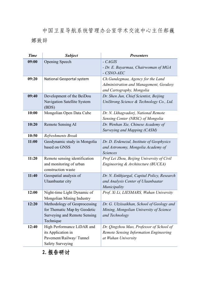
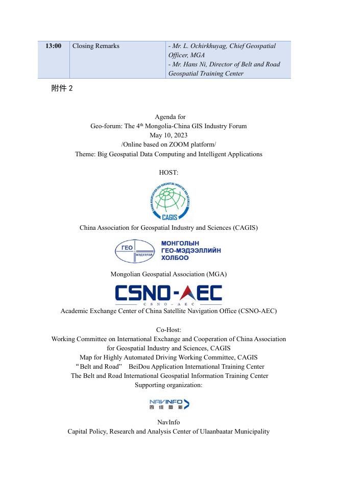
附件 1 第四届中蒙地理信息产业发展论坛议程 论坛时间:2023 年 5 月 10 日 09:00 - 13:00 论坛地点:Zoom 线上平台 论坛语言:英语 主办单位: 中国地理信息产业协会 蒙古国地理信息协会 中国卫星导航系统管理办公室学术交流中心 承办单位: 中国地理信息产业协会国际交流与合作工作委员会 中国地理信息产业协会高精地图服务工作委员会 “一带一路”北斗应用国际培训中心 “一带一路”地理信息国际培训中心 支持单位: 北京四维图新科技股份有限公司 乌兰巴托研究中心 蒙古国生命科技大学 会议日程: 1.开幕致辞 中国地理信息产业协会会长李维森致辞 蒙古国地理信息协会主席 Dr. E. Bayarmaa 致辞 中国卫星导航系统管理办公室学术交流中心主任郝巍 娜致辞 Time 09:00 Subject Opening Speech 09:20 National Geoportal system 09:40 10:00 Development of the BeiDou Navigation Satellite System (BDS) Mongolian Open Data Cube 10:20 Remote Sensing AI 10:50 11:00 Refreshments Break Geodynamic study in Mongolia based on GNSS 11:20 Remote sensing identification and monitoring of urban construction waste Geospatial analysis of Ulaanbaatar city 11:40 12:00 12:20 12:40 Night-time Light Dynamic of Mongolian Mining Industry Methodology of Geoprocessing for Thematic Map by Geodetic Surveying and Remote Sensing Technique High Performance LiDAR and its Application in Pavement/Railway/ Tunnel Safety Surveying 2.报告研讨 Presenters - CAGIS - Dr. E. Bayarmaa, Chairwoman of MGA - CSNO-AEC Ch.Gundegmaa, Agency for the Land Administration and Management, Geodesy and Cartography, Mongolia Dr. Shen Jun, Chief Scientist, Beijing UniStrong Science & Technology Co., Ltd. Dr. N. Lkhagvadorj, National Remote Sensing Center (NRSC) of Mongolia Dr. Wenhan Xie, Chinese Academy of Surveying and Mapping (CASM) Dr. D. Erdenezul, Institute of Geophysics and Astronomy, Mongolia Academy of Sciences Prof Lei Zhou, Beijing University of Civil Engineering & Architecture (BUCEA) Dr. N. Enkhjargal, Capital Policy, Research and Analysis Center of Ulaanbaatar Municipality Prof. Xi Li, LIESMARS, Wuhan University Dr. G. Ulziisaikhan, School of Geology and Mining, Mongolian University of Science and Technology Dr. Qingzhou Mao, Professor of School of Remote Sensing Information Engineering at Wuhan University 13:00 Closing Remarks - Mr. L. Ochirkhuyag, Chief Geospatial Officer, MGA - Mr. Hans Ni, Director of Belt and Road Geospatial Training Center 附件 2 Agenda for Geo-forum: The 4 Mongolia-China GIS Industry Forum May 10, 2023 /Online based on ZOOM platform/ Theme: Big Geospatial Data Computing and Intelligent Applications th HOST: China Association for Geospatial Industry and Sciences (CAGIS) Mongolian Geospatial Association (MGA) Academic Exchange Center of China Satellite Navigation Office (CSNO-AEC) Co-Host: Working Committee on International Exchange and Cooperation of China Association for Geospatial Industry and Sciences, CAGIS Map for Highly Automated Driving Working Committee, CAGIS “Belt and Road” BeiDou Application International Training Center The Belt and Road International Geospatial Information Training Center Supporting organization: NavInfo Capital Policy, Research and Analysis Center of Ulaanbaatar Municipality School of Geology and Mining, Mongolian University of Science and Technology Time 09:00 09:20 09:40 10:00 10:20 10:50 11:00 11:20 11:40 12:00 12:20 12:40 13:00 Subject Opening Speech Presenters - CAGIS - Dr. E. Bayarmaa, Chairwoman of MGA - CSNO-AEC National Geoportal system Ch.Gundegmaa, Agency for the Land Administration and Management, Geodesy and Cartography, Mongolia Development of the BeiDou Dr. Shen Jun, Chief Scientist, Beijing Navigation Satellite System UniStrong Science & Technology Co., (BDS) Ltd. Mongolian Open Data Cube Dr. N. Lkhagvadorj, National Remote Sensing Center (NRSC) of Mongolia Remote Sensing AI Dr. Wenhan Xie, Chinese Academy of Surveying and Mapping (CASM) Refreshments Break Geodynamic study in Dr. D. Erdenezul, Institute of Geophysics Mongolia based on GNSS and Astronomy, Mongolia Academy of Sciences Remote sensing identification Prof Lei Zhou, Beijing University of Civil and monitoring of urban Engineering & Architecture (BUCEA) construction waste Geospatial analysis of Dr. N. Enkhjargal, Capital Policy, Ulaanbaatar city Research and Analysis Center of Ulaanbaatar Municipality Night-time Light Dynamic of Prof. Xi Li, LIESMARS, Wuhan Mongolian Mining Industry University Methodology of Dr. G. Ulziisaikhan, School of Geology Geoprocessing for Thematic and Mining, Mongolian University of Map by Geodetic Surveying Science and Technology and Remote Sensing Technique High Performance LiDAR and Dr. Qingzhou Mao, Professor of School of its Application in Remote Sensing Information Engineering Pavement/Railway/ Tunnel at Wuhan University Safety Surveying Closing Remarks - Mr. L. Ochirkhuyag, Chief Geospatial Officer, MGA - Mr. Hans Ni, Director of Belt and Road Geospatial Training Center 公开方式:公开 抄送:蒙古国地理信息协会、中国卫星导航系统管理办公室学术交流 中心、北京四维图新科技股份有限公司、乌兰巴托研究中心、蒙古国 生命科技大学 中国地理信息产业协会 2023 年 3 月 13 日印发